


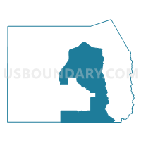
Terra Voting District, Tooele County, Utah
About
Outline

Summary
| Unique Area Identifier | 680021 |
| Name | Terra Voting District |
| County | Tooele County |
| State | Utah |
| Area (square miles) | 1,485.38 |
| Land Area (square miles) | 1,485.31 |
| Water Area (square miles) | 0.07 |
| % of Land Area | 100.00 |
| % of Water Area | 0.00 |
| Latitude of the Internal Point | 40.34499380 |
| Longtitude of the Internal Point | -112.85464320 |
Maps


Graphs
Select a template below for downloading or customizing gragh for Terra Voting District, Tooele County, Utah


Neighbors
Neighoring Voting District (by Name) Neighboring Voting District on the Map
- Callaco Voting District, Juab County, UT
- Dugway 01 Voting District, Tooele County, UT
- Dugway 02 Voting District, Tooele County, UT
- Eureka Voting District, Juab County, UT
- Grantsville 01 Voting District, Tooele County, UT
- Grantsville 04 Voting District, Tooele County, UT
- Ibapah Voting District, Tooele County, UT
- Lake Point 01 Voting District, Tooele County, UT
- Rush Valley Voting District, Tooele County, UT
- Stockton 02B Voting District, Tooele County, UT
- Vernon Voting District, Tooele County, UT
- Wendover Voting District, Tooele County, UT
Top 10 Neighboring County Subdivision (by Population) Neighboring County Subdivision on the Map
- Tooele-Grantsville CCD, Tooele County, UT (54,800)
- Dugway-Wendover CCD, Tooele County, UT (2,477)
- Rush Valley CCD, Tooele County, UT (941)
- West Juab CCD, Juab County, UT (187)
Top 10 Neighboring Place (by Population) Neighboring Place on the Map
Top 10 Neighboring Unified School District (by Population) Neighboring Unified School District on the Map
Top 10 Neighboring State Legislative District Lower Chamber (by Population) Neighboring State Legislative District Lower Chamber on the Map
Top 10 Neighboring State Legislative District Upper Chamber (by Population) Neighboring State Legislative District Upper Chamber on the Map
- State Senate District 13, UT (150,707)
- State Senate District 17, UT (102,922)
- State Senate District 24, UT (85,639)
Top 10 Neighboring 111th Congressional District (by Population) Neighboring 111th Congressional District on the Map
Top 10 Neighboring Census Tract (by Population) Neighboring Census Tract on the Map
- Census Tract 1307.03, Tooele County, UT (6,997)
- Census Tract 102, Juab County, UT (4,681)
- Census Tract 1306, Tooele County, UT (2,477)
- Census Tract 9800, Tooele County, UT (0)